
34 of the 328 sites offered for West Suffolk's next Local Plan are in Bury, including the rugby club and a council car park. Higham is bid as a new town.
West Suffolk Council has published every site that developers and landowners want considered for its next Local Plan. There are 328, and 34 entries in the council’s table are in Bury St Edmunds itself.
The council stresses that no decisions have been made. This is a list of offers, not a plan. But it shows for the first time where land could be built on around the town over the next two decades, and some of the entries are places people know well.
The council published the details on 30 September, with a map and a full table (West Suffolk Council, submission table).
The sites inside Bury St Edmunds
The table files 34 entries under Bury St Edmunds. Some overlap: the land south of Rougham Hill appears twice at 108 hectares, once for housing and once for housing with green space, and land north-east of the town comes as an Option A and an Option B.
Some of the smaller entries are inside the town:
- Bury Rugby Club, 6.21 hectares, put forward for housing
- Land on the south side of Olding Road, described in the table as the “current West Suffolk Council car park”, 1 hectare, for housing, employment and other uses
- Signal Point, Station Hill, 3.35 hectares, for housing, employment and other uses
- Westley Middle School, 6.6 hectares, and separately land at the former Westley Middle School, 4.2 hectares, both for housing
- The former Riverwalk School site, 0.72 hectares, for housing
- The former discount superstore on Anglian Lane, 0.87 hectares, for housing and employment
- Land at 136 Newmarket Road, 0.4 hectares, for housing
The big ones are on the edges of the town:
| Site | Hectares | Proposed use |
|---|---|---|
| Three New Suffolk Villages, east of Bury St Edmunds | 329 | Housing, employment, infrastructure, green space |
| Land north-east of Bury St Edmunds, Option A | 132 | Housing, employment, infrastructure, green space |
| Land east of Westley Lane | 117 | Housing, green space |
| Land south of Rougham Hill | 108 | Housing (a second entry adds green space) |
| Land at junction 42 of the A14 | 107.01 | Housing, employment, infrastructure, green space |
| Land at Honey Hill (west) | 90.35 | Employment and commercial |
| Land at Rougham Tower Avenue, Rushbrooke with Rougham | 63.19 | Housing, employment, infrastructure, green space |
| Land north-east of Bury St Edmunds, Option B | 51 | Housing, employment, infrastructure, green space, other |
Other edge sites, mostly for housing, include land at Horringer Road (15.81 hectares), two on Mount Road (18.2 and 18.71), land south of Home Farm Lane (18.22), land at Newmarket Road west (20.58) and Bridge Farm on Sicklesmere Road (10.25). Westfield Farm on Compiegne Way (21.58) and two expansions of Fornham Business Court (4.82 and 7.77) are offered for employment.
The table does not say who submitted each site. The council notes that “sites have not necessarily been submitted by the landowner”.
A new town at Higham, and 424 hectares at Fornham
The single largest entry in the district is “Higham Market Town”, at 1,032 hectares, for housing, employment, infrastructure, green space and other uses. Higham is a village about seven miles west of Bury, beside the A14. The table gives no further detail.
The second largest is Hall Farm, Fornham St Martin, on the northern edge of Bury, at 424 hectares for housing and employment. The table lists six more entries at Fornham St Martin and one at Fornham All Saints.
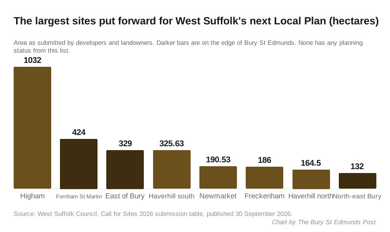
Elsewhere in the district, the biggest entries are:
- “Haverhill Vales”, land south of the A1017 at Haverhill, 325.63 hectares, mixed use
- land west of Hamilton Road, Newmarket, 190.53 hectares, offered for a racecourse and horse racing uses rather than housing
- land south of Mildenhall Road, Freckenham, 186 hectares, mixed use
- land north of Haverhill, 164.5 hectares, mixed use
What the whole list contains
The council’s press release gives 328 sites. Its table has 330 rows, because some sites are entered more than once. By the use each row proposes:
- 216 for housing only
- 84 for a mix of uses
- 23 for employment and commercial use
- 7 for infrastructure, green space or other uses
The council has to find land for around 1,200 new homes a year, the figure the government’s housing need assessment sets for West Suffolk.
What happens next
The current West Suffolk Local Plan was adopted only in July 2025. The new one is being prepared to run to 2045. The steps the council has published are:
- Later this autumn: an initial assessment of every housing and employment site, to see which are suitable, available and deliverable. It will be published as a strategic housing and economic land availability assessment. The council says this “will not determine which sites are included in the local plan”.
- Mid-2027: public consultation on the spatial strategy, the overall pattern of where growth should go across the district.
- 2028: consultation on a draft version of the plan.
Cllr Frank Stennett, the cabinet member for planning, said: “We are still at a very early stage in the preparation of the next local plan. No decisions have been made on any sites.”
What it means for you
- Nothing on this list has planning permission because of the list. Sites “have no planning status”, the council says, other than those already allocated or already approved.
- You cannot comment yet. The call for sites closed on 20 May and the council is not taking late submissions. Your first chance to respond is the spatial strategy consultation in mid-2027.
- To see whether land near you is on the list, use the council’s Find my nearest map and choose the “Call for Sites 2026” layer. Clicking a site shows the use proposed.
- To be told when consultations open, register on the council’s local plan consultation system.
We will report the council’s site assessment when it is published. For decisions on current applications, see our Bury St Edmunds planning news page.
Have your say